Site Information
Hub Lake
 Classification: Lake
Latitude: 47.2752°
Longitude: -115.3766°
Elevation: 5969 ft.
Area: Saint Regis South
Season Start: Late Spring End: Early Fall
Difficulty: Moderate
Legal Description: T18N,R30W,sec35 MT
UTMZone: 622783, 5237025
Directions:
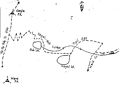
See Hub-Hazel Lakes Trail-USFS No 280
Alternate Directions:
From eastbound I-90 near DeBorgia, MT take exit 26. Take Forest Road No. 889, Ward Creek Road south for 6.5 miles. The trail head is on the right side where the road crosses Ward Creek.
Narrative:
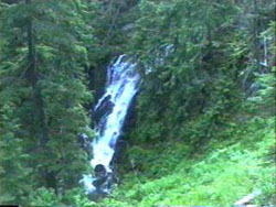
Easy access makes this a nice one day outing. It has all the scenery you could ask for; nice views near the Idaho-Montana divide, a cedar forest at the beginning of the trail, several stream crossings, a waterfall, a couple of alpine lakes, decent campsites and you might want to try your luck fishing for cutthroat trout in Hub Lake.
Connections: Hazel Lake, Hazel-hub Lakes Trail 280, Square Lake
Trail Map:
|
Trail Profile:
|
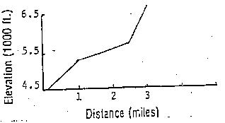
Photo:
|
The 7.5 minute series USGS topographic maps for that area
| Saltese | Haugan | De Borgia North |
| Adair |
McGee Peak SE | De Borgia South |
| ? | ? | Berge Peak |
Switch to TerraServer - Topo Map
Switch to TerraServer - Aerial Photo(If Avail.)
Switch to Maptech MapServer
Switch to TopoZone MapServer
Switch to TopoWest Quad MapServer